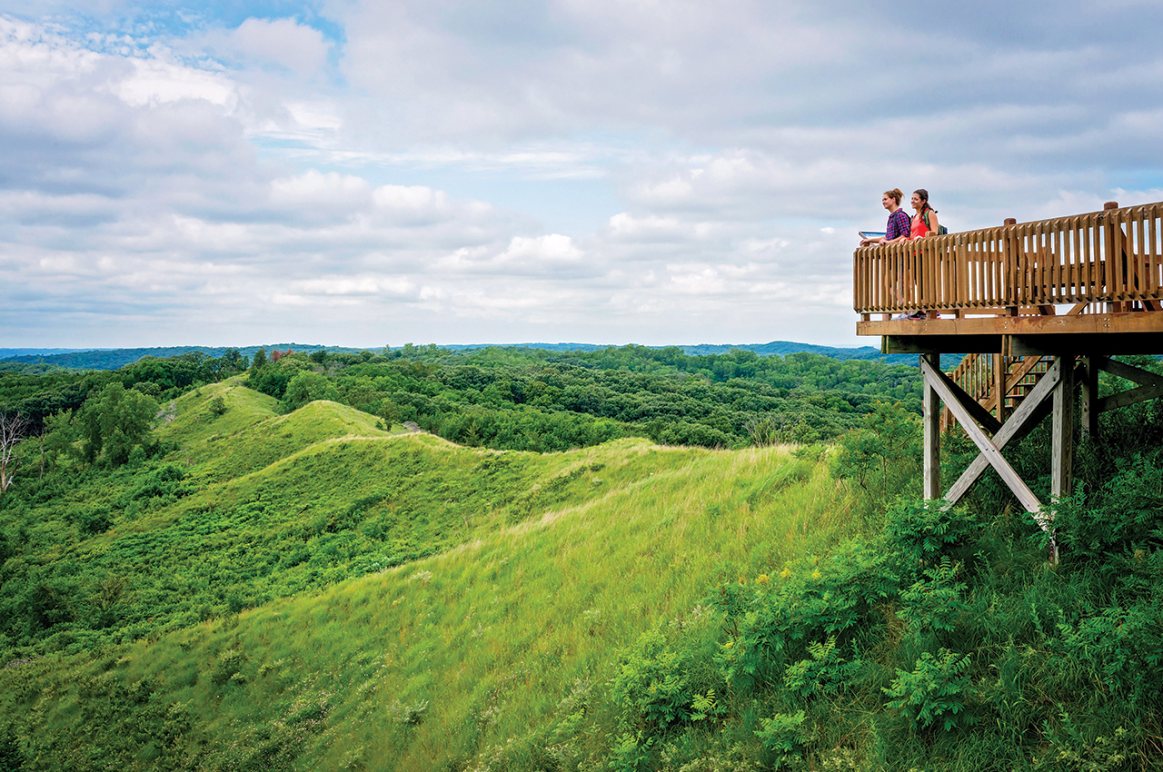
Above: Loess Hills State Forest near Pisgah gives hikers plenty of room to roam the area’s steep ridges, prairies and woods. The latest attraction is Brent’s Trail, an 8-mile trek through the scenic hills. Photograph courtesy of Iowa Tourism Office
Writer: Beth Eslinger
Native Prairie, Diverse Habitats
The Loess Hills, Western Iowa
Famous for its razor-edge ridges, peaks and saddles, the Loess Hills framing the western border of the state offer a haven for hikers and nature enthusiasts. Created during the last ice age, glacial flour was deposited east of the Missouri River, creating thick dunes of sugar-sand soil that’s rich for outdoor adventure. As University of Iowa professor Bohumil Shimek wrote in his 1909 geological survey of the region, “the billowy expanses of the inland loess ridges … appear like the giant swell of a stormy sea which has been suddenly fixed.”
Throughout the hills, which are globally significant, parks and recreation areas allow visitors to explore the unique geology and habitats that support a diversity of plants, animals and insects. Birds are a major attraction here; 249 species have been identified in the area.
New in 2019, Brent’s Trail connects several pockets of public land for an 8-mile hike (and that’s one-way). Named after Brent Olson, who worked as manager of Loess Hills State Forest and Preparation Canyon State Park before his death in 2016, the trail winds through the heart of the hills near Little Sioux. Considered a serious hike, Brent’s Trail weaves through native prairie, dense woods, savannas and steep hillsides, some with drops and then inclines of several hundred feet.
The undulating trail connects with Murray Hill Scenic Overlook to the north, where yucca and other native wildflowers color the hills in summer. The Loess Hills State Forest makes up a majority of the hike’s terrain (the four units in the preserve feature additional trekking options). The trail ends to the south at Gleason-Hubel Wildlife Area, also part of the state forest and a great spot for observing woodland birds.
On the northeast border of the state forest, Preparation Canyon State Park rewards backpackers with 10 hike-in campsites, some accessible via a short walk. Trek the narrow ridge to the scenic overview, which displays 360-degree views of the prairie and burr oak forest. Fall is one of the most picturesque times to visit this area.
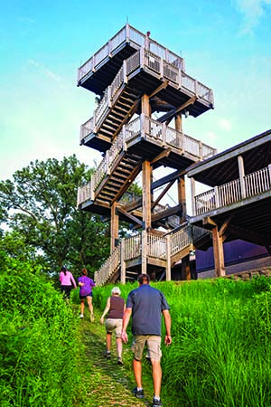
A top spot to see area birds is at Hitchcock Nature Center in Honey Creek. Climb the 45-foot observation tower to view soaring eagles and hawks. More than 500 eagles migrate through here each year, and it’s one of the top hawk-watching sites in the world (Hawkwatch in September is a prime time to visit).
Hiking lures visitors here, too. Ten miles of easy to advanced paths lead through the Pottawattamie conservation center park.

Dense Woods, Sandstone Canyons
The Des Moines and Raccoon River Watersheds, Central Iowa
Within an hour of Des Moines, three park and rec areas—Dolliver Memorial State Park, Whiterock Conservancy and Ledges State Park—make for easy day trips for hikes and experiencing state culture.
Located 23 miles south of Fort Dodge, Dolliver greets visitors with dense woods of upland oak, restored prairie and wetlands for birding. Prehistoric tribes lived in this canyon edging the Des Moines River and hunted the area’s rich habitat for bison, elk and deer. It’s believed they ran the animals off the sandstone cliffs for an easy harvest.
Early European settlers discovered the animals’ bones, naming this section Boneyard Hollow; the 1-mile trail runs through the narrow canyon and connects to the river trail adjacent for a short loop hike. The area is stunning, with steep layers of stone in ochres, tans and greens; you can hike into the canyon or study it from above.
All of the park’s trails connect for a 5- to 6-mile loop. Another geological highlight, the Copperas Beds trail winds through the Pennsylvanian-age sandstone sediment that towers about 100 feet above Prairie Creek. Interpretive signage explains the geology of the ancient riverbed eroded over the past 150 million years. Mineral deposits, petrified logs and sticks penetrate the sandstone. Iowa’s third state park (Backbone came first and Ledges came next), Dolliver features the hallmark Civilian Conservation Corps stone-and-timber structures defining many of the early parks. Here, moss layers the stairs leading up the canyon walls and makes for dramatic photo ops.
More rustic structures, paths and bridges built by the CCC stand amid the natural beauty of Ledges State Park 7 miles south of Boone. Hikers can scramble down the stone stairs to Pea Creek; kids of all ages love to explore the creek and the steep sandstone walls carved by glacial melt 12,000 to 14,000 years ago. Hikes lead up the canyon on both sides of the creek, with top views at Crow’s Nest, Table Rock and Inspiration Point. The park welcomes guests in all seasons, with fresh spring blooms and mosses carpeting the forest floor, a bright green canopy shading the trails in summer, falling oak leaves in autumn, and icy overlooks in winter.
For more area geology, stroll through the walk-in campsites to see the ruins of an old settlement. A stone fireplace and foundation remain and show off the stonemason’s handiwork. To see some of the state’s diverse species of prairie plants, hike through the restored section near the park entrance. Nearly 400 species of plants and numerous insects and pollinators call this area home. Birders will want to make the mile journey to Lost Lake to see ducks, geese, eagles and other species—it’s possible to see the Des Moines River from this trail.
Donated by the Garst family, Whiterock Conservancy just outside of Coon Rapids delivers stellar hiking, plus mountain biking, paddling, fishing and stargazing. With 45 miles of trails through oak savanna and restored prairie, the conservancy treats trekkers and runners with plenty of opportunities to get in 10,000 steps.
A number of multiuse trails, each marked easy to moderate, edge the Middle Raccoon River. Smaller loops climb through woodlands. For a break from the trekking, visitors can float the river or cruise the trails via mountain bike (bikes, canoes and kayaks available for rent).
Rugged Bluffs, Mystical Mounds
The Driftless Area, Northeast Iowa
Photographs courtesy of Iowa Tourism Office
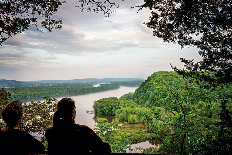
The far northeast corner of the state—known for its soaring limestone bluffs, meandering trout streams, dense forests and rich Native American culture—offers numerous trails to explore. In the early 1900s, the area hugging the Mississippi River in Allamakee and Clayton counties was revered for its beauty and considered as a potential national park.
Though not adopted due to the number of towns and cities breaking up the proposed parkland tract, Effigy Mounds National Monument, Yellow River State Forest and Pike’s Peak State Park all resulted from the effort. Today, these three parks—all within a 20-minute drive—offer more than 50 miles of hiking trails through wooded, hilly terrain for the ultimate trekking weekend.
Effigy Mounds, about 3 miles north of Marquette, is a must-visit for hikers interested in history, nature and culture. Iowa’s only national monument, the park is home to Native American burial mounds in the shapes of bears, birds, cones and lines constructed between 850 and 1400 AD. The shapes were symbolic to the people who created them: The bear is like the earth, and birds represent freedom, dignity and beauty.
Fifteen miles of trails, some steep, lead to the mounds. A hike here is mystical and magical in all four seasons. In spring, wildflowers carpet the forest floor, with migrating birds flitting among the trees. Summer brings out the leafy canopy and multiple shades of green. Fall color peaks here in mid-October, with sugar and silver maples lighting the woods in reds and oranges (subscribe to the DNR’s weekly fall color updates at iowadnr.gov). In winter, a hike through the snow offers serenity, with eagles and redheaded woodpeckers, quaking trees and deer sharing their habitat with visitors. Several overlooks provide epic views of the Mississippi River islands and bluffs.
Located about 8 miles south of Effigy Mounds, Pike’s Peak State Park near McGregor celebrates Zebulon Pike, who explored this area in 1805 in search of a fort location. His named peak towers 500 feet above the confluence of the Wisconsin and Mississippi rivers. Decking on the limestone bluff provides views of bald eagles, pleasure cruisers, fishing boats and barges. In 1846 Charles Lanman wrote of the region: “That portion of the Mississippi which extends from Prairie du Chein to Lake Pepin is the most mountainous and truly beautiful on the whole river, and may with strict propriety be called the Alpine Region.”
While Pike’s Peak attracts the most visitors, its 11.5 miles of trails let hikers escape from the crowds. It’s possible to park north of McGregor and hike from Point Ann, which overlooks the town of McGregor, to Pike’s Peak, exploring small waterfalls and ancient burial grounds.
Study the limestone edging the trail to find sea-life fossils such as brachiopods and cephalopods (though no collecting in the parks).
And for those looking to trek with minimal human contact, Yellow River State Forest, about 6 miles west of Harpers Ferry, treats visitors with more than 25 miles of trails, some leading to backcountry camping sites. (Backpacker magazine noted the Backpack Trail as the best hike in the state.)
Terrain here is rugged, with steep slopes, limestone bluffs and V-shape valleys. You can reach Paint Creek and Little Paint Creek (both are great for trout angling) from several access points. Some of the trails in the park allow mountain biking and equestrian use.


